Rambøll Norway AS
https://www.ramboll.com/
Rambøll is an international knowledge-based consultancy firm with Nordic roots and more than 17,000 employees located in 35 countries. Based on experience, expertise, innovation, consistent work methods and interdisciplinary teamwork, we offer knowledge-based consultancy with quality and value
for public and private customers.
Rambøll Norway is a part of Rambøll (Rambøll Group) and has around 1,600 employees who offers acomplete set of knowledge-based consultancy services within the areas of technical, property and architectural consultancy, environmental consultancy, management consultancy and energy consultancy. Rambøll Norway locates in 18 offices through the country and our well qualified employees are engaged in projects all over the country. We combine a strong and broad presence with the possibility of obtaining specialized expertise and additional capacity from other parts of the Rambøll Group in the project where this is useful. Our goal is to be an innovative, creative, and sustainable partner while ensuring functional, safe and reliable solutions through broad competence.
GIS, Geomatics & Visualization is a department within Rambøll Norway with expertise in map production, GIS, Geomatics and 3D-visualization/XR (VR/AR/MR) solutions. The department has 24 years of experience in producing and managing geospatial data. The employees have extensive
knowledge in map production and use of tools related to geographic information systems, as well as being global spearhead for Visualization through the Rambøll Group through 18 years. Based on public geographic data sources, we prioritize accuracy and maintain high standards for visual quality.
Rambøll Interactive https://rambollvisualization.com/ramboll-interactive/
Our visualization team has developed an innovative interactive presentation model called Rambøll Interactive. Leveraging the power of the market-leading game engine, Unreal Engine, we ensure the same exceptional precision and stunning visual fidelity in our interactive models. This is a design and production tool for high-quality real-time renderings. Combined with sensor data, information from REST API’s and other geospatial information it serves as an advanced fully 3D Digital Twin. This powerful tool enables us to provide stakeholders with an immersive experience in which viewers can explore and interact with the planning concepts, gaining a comprehensive understanding of the project’s development and its impact. Rambøll Interactive offers a dynamic visual representation that enhances communication, facilitates informed decision-making and effectively engages the public,
including the youth. Rambøll Interactive supports VR and can be used standalone for meetings, presentations and seminars, or could be integrated into a customer’s website or services, further extending its versability. We are proud of our ability to deliver models, 3D films and illustrations that are
both accurate and aesthetically appealing, which are of great assistance to our customers in their planning and decision-making processes as well as for communicating to the public. Unreal Engine allows us to create and develop interactive experiences of tailored scenarios unique to each project.
From 3D visualization and cinematic experiences to interactive project and design analyses, Unreal Engine gives us the ability to turn the customer’s ideas into reality. The default package has basic tools and a user-friendly interface. This package can be expanded upon and further developed to match the
customer’s needs. Functions include:
• High quality visual graphics in Real Time
• Navigating the model using VR glasses
• Navigate in walking or flying mode
• Drive by car
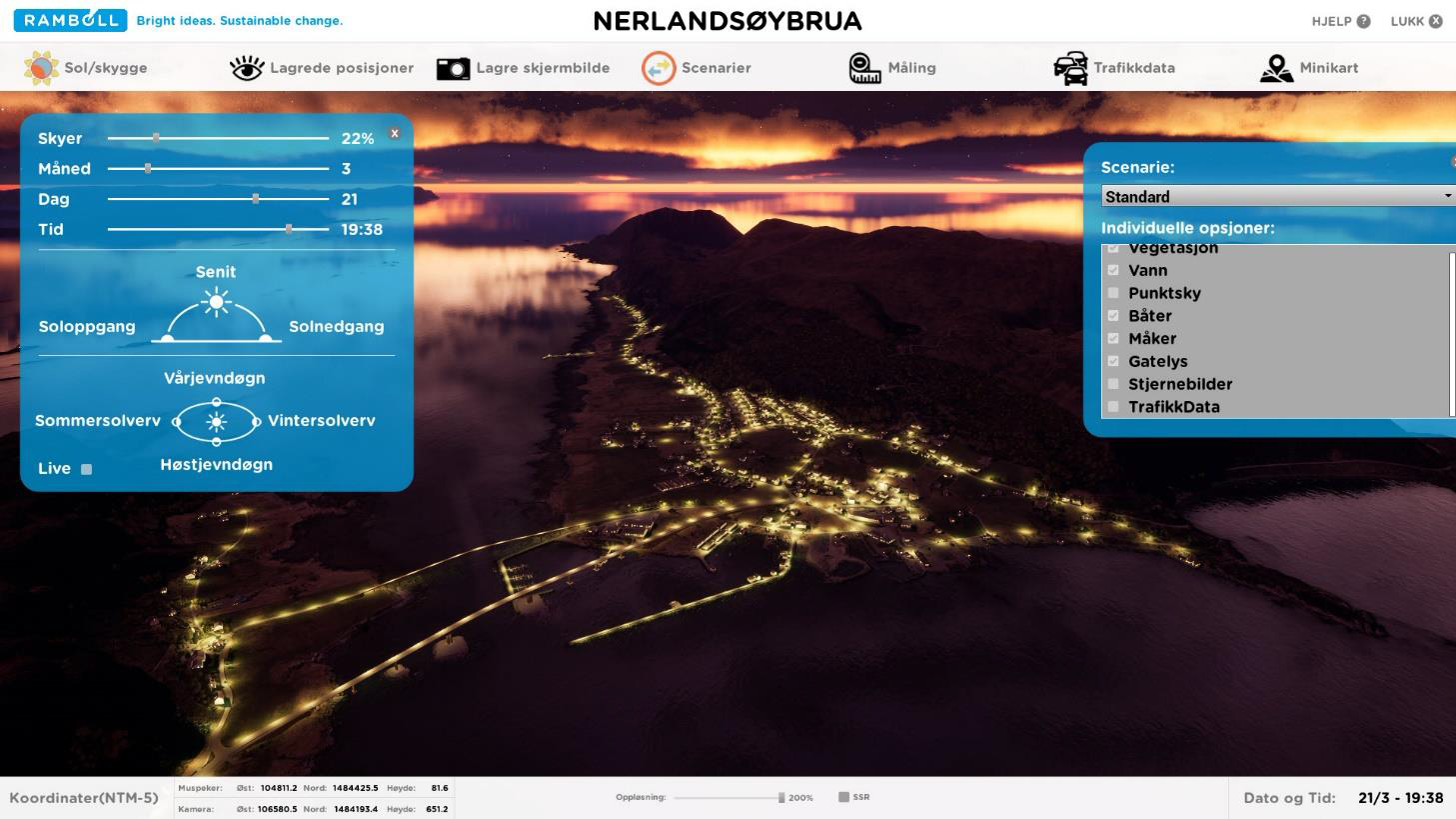
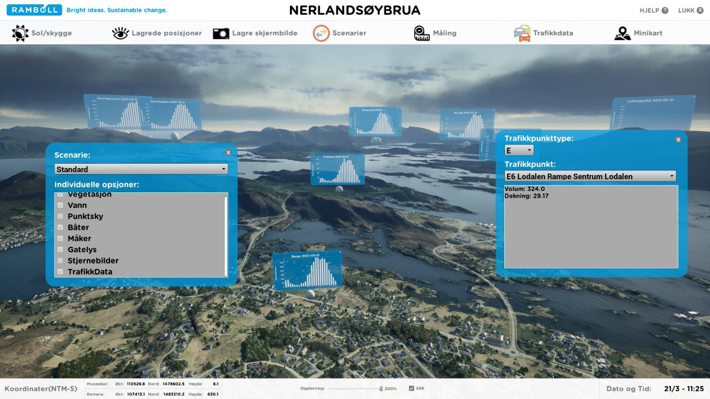
• Visibility analyses: 100% freedom from viewing the project from any position
• Sun-shadow analysis: Set sun to any date and time. Realistic light.
• Save camera positions
• Export images up to 4K resolution
• Layer structure and scenarios